본문 영역
본문
모델소개
University of Arizona Solar Irradiance Based on Satellite – KIER
천리안 위성영상을 이용하여 지표에 도달하는 일사량을 산정하는 모델입니다 2014년도 University of Arizona (애리조나 대학교)에서 최초 개발된 모델로 애리조나 및 네바다 지역의 일사량을 산정하는데 탁월한 성능을 보였고, 이 후 한국에너지기술연구원과의 협력을 통해 천리안 위성영상을 활용하는 UASIBS-KIER 모델이 개발되었습니다.
UASIBS-KIER 생산 데이터
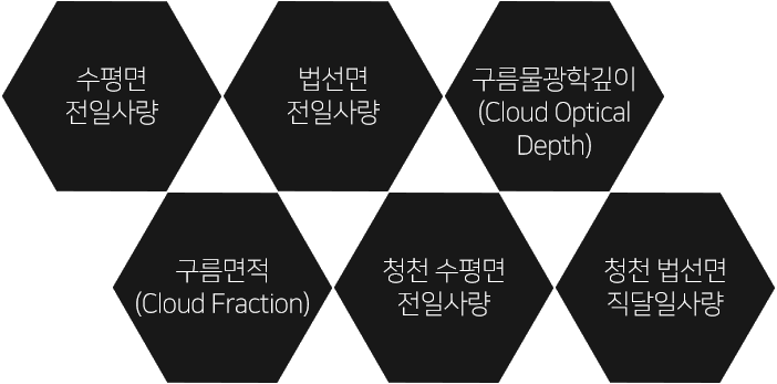
- 수평면 전일사량
- 법선면 전일사량
- 구름물광깊이(Cloud Optical Depth)
- 구름면적(Cloud Fraction)
- 청천 수평면 전일사량
- 청천 볍선면 직달일사량
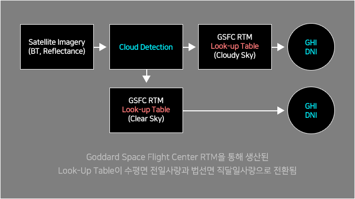
생산체계
UASIBS-KIER 모델 생산 체계
UASIBS-KIER 모델 성능
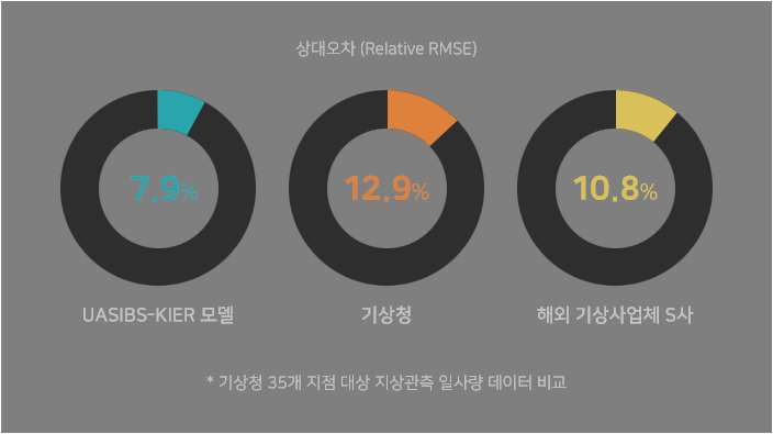
- UASIBS-KIER 모델 : 7.9%
- 기상청 : 12.9%
- 해외 기상사업체 S사 : 10.8%
소개논문
해외 저널을 통해 UASIBS-KIER 모델의 우수성을 입증하고 이 모델을 활용한 신재생에너지 예보체계 구축했습니다.
-
Kim, C. K., W. F. Holmgren, M. Stovern, and E. A. Betterton, 2016: Toward Improved Solar Irradiance Forecasts: Derivation of Downwelling Surface Shortwave Radiation in Arizona from Satellite. Pure Appl. Geophys., 173, 2535-2553. -
Kim, C. K., H.-G. Kim, Y.-H. Kang, and C.-Y. Yun, 2017: Toward Improved Solar Irradiance Forecasts: Comparison of the Global Horizontal Irradiances Derived from the COMS Satellite Imagery Over the Korean Peninsula. Pure Appl. Geophys., 174, 2773-2792. -
Lorenzo, A. T., M. Morzfeld, W. F. Holmgren, and A. D. Cronin, 2017: Optimal Interpolation of Satellite and Ground Data for Irradiance Nowcasting at City Scales. Solar Energy, 144, 466-474.
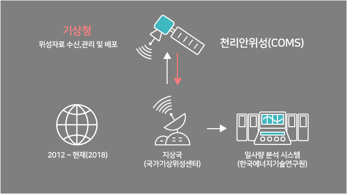
이미지 출처 : 한국항공우주연구원